智能应用
影音
科技网
推荐
编辑推荐
大南方崛起专题报导
最新活动
人形机器人 Special Report
供应链
苹果供应链
未来车供应链
每日椽真
报导总览
产业
半导体.零组件
光电.显示.光学
物联科技.智能制造
CarTech.绿能
移动.通讯.XR
AI.智能应用.电商物流
IT.系统供应链
科技政策
观点
图表
区域
东南亚
印度
东亚/中国
国际
图表
椽经阁
Colley & Friends
作者群
议题专区
新闻放大镜
2023苹果秋季发表会
数码健康
智能城市
AsiaTech Frontier
苹果Vision Pro 供应链
Google I/O 2023
贸易战升温
矽岛春秋
Daily Issue
精选议题
商情
科技商情
GenAI
产业研究
研究报告
AI&IOT
智能制造
智能家庭
物联网
AI Focus
通讯与云端
宽频与无线
B5G及垂直应用
Cloud
运算
电脑运算
服务器
边缘运算
HPC关键零组件
半导体及显示科技
IC 制造
IC 设计
化合物/功率半导体
显示科技与应用
新兴市场与产业布局
Green Tech
亚洲供应链
新兴科技
未来车
CarTech
EV Focus
车用零组件
移动装置与应用
移动设备与应用
智能穿戴
全球产业数据数据库
电脑运算
服务器
移动设备与应用
IC 制造
IC 设计
CarTech
显示科技与应用
宽频与无线
加值服务
到府简报
Special Report
人形机器人 Special Report
顾问专案
影音
影音节目
科技椽送门
论坛
活动家
DIGITIMES 主办
智能应用
云端 & 网安
产品 & 研发
AI & 创新
其他
AI EXPO Taiwan
在线订阅
苹果供应链
未来车供应链
Special Report
人形机器人 Special Report
DIGITIMES移动版订阅
D-Book 订阅
DIGITIMES Asia
Tech
Regions
Research
Opinions
Finance
Biz Focus
Event+
Multimedia
AI+
服务专区
会员服务
整合行销服务
展会服务
科技产业报订阅
繁体版
简体版
登入
科技网
推荐
编辑推荐
大南方崛起
最新活动
人形机器人 Special Report
供应链
苹果供应链
未来车供应链
每日椽真
报导总览
产业
半导体.零组件
光电.显示.光学
物联科技.智能制造
CarTech.绿能
移动.通讯.XR
AI.智能应用.电商物流
IT.系统供应链
科技政策
观点
图表
区域
东南亚
印度
东亚/中国
国际
图表
椽经阁
Colley & Friends
作者群
议题专区
新闻放大镜
2023苹果秋季发表会
数码健康
智能城市
AsiaTech Frontier
苹果Vision Pro 供应链
Google I/O 2023
贸易战升温
矽岛春秋
Daily Issue
精选议题
商情
科技商情
产业研究
研究报告
AI & IOT
智能制造
智能家庭
物联网
AI Focus
通讯与云端
宽频与无线
B5G及垂直应用
Cloud
运算
电脑运算
服务器
边缘运算
HPC关键零组件
半导体及显示科技
IC 制造
IC 设计
化合物/功率半导体
显示科技与应用
新兴市场与产业布局
Green Tech
亚洲供应链
新兴科技
未来车
CarTech
EV Focus
车用零组件
移动装置与应用
移动设备与应用
智能穿戴
全球产业数据数据库
电脑运算
服务器
移动设备与应用
IC 制造
IC 设计
CarTech
显示科技与应用
宽频与无线
加值服务
到府简报
Special Report
人形机器人 Special Report
顾问专案
影音
影音节目
科技椽送门
论坛
活动家
DIGITIMES 主办
研究中心
产业研讨会
AI EXPO Taiwan
在线订阅
苹果供应链
未来车供应链
Special Report
人形机器人 Special Report
DIGITIMES移动版订阅
D-Book 订阅
DIGITIMES Asia
Tech
Regions
Research
Opinions
Finance
Biz Focus
Event+
Multimedia
AI+
服务专区
会员服务
整合行销服务
展会服务
科技产业报订阅
热门关键字
#电动车
#AI PC
#NB
#服务器
#半导体
#陈玉娟
#AI
#存储器
#台积电
#联发科
科技网
推荐
编辑推荐
大南方崛起
最新活动
人形机器人 Special Report
供应链
苹果供应链
未来车供应链
每日椽真
报导总览
产业
半导体.零组件
光电.显示.光学
物联科技.智能制造
CarTech.绿能
移动.通讯.XR
AI.智能应用.电商物流
IT/云端
科技政策
观点
图表
区域
东南亚
印度
东亚/中国
国际
图表
椽经阁
Colley & Friends
作者群
议题专区
新闻放大镜
2023苹果秋季发表会
数码健康
智能城市
AsiaTech Frontier
苹果Vision Pro 供应链
Google I/O 2023
贸易战升温
矽岛春秋
Daily Issue
精选议题
商情
科技商情
产业研究
研究报告
AI & IOT
智能制造
智能家庭
物联网
AI Focus
通讯与云端
宽频与无线
B5G及垂直应用
Cloud
运算
电脑运算
服务器
边缘运算
HPC关键零组件
半导体及显示科技
IC 制造
IC 设计
化合物/功率半导体
显示科技与应用
新兴市场与产业布局
Green Tech
亚洲供应链
新兴科技
未来车
CarTech
EV Focus
车用零组件
移动装置与应用
移动设备与应用
智能穿戴
全球产业数据数据库
电脑运算
服务器
移动设备与应用
IC 制造
IC 设计
CarTech
显示科技与应用
宽频与无线
加值服务
到府简报
Special Report
人形机器人 Special Report
顾问专案
影音
影音节目
科技椽送门
论坛
活动家
DIGITIMES 主办
智能应用
云端 & 网安
产品 & 研发
AI & 创新
其他
AI EXPO Taiwan
在线订阅
苹果供应链
未来车供应链
Special Report
人形机器人 Special Report
DIGITIMES移动版订阅
D-Book 订阅
DIGITIMES Asia
Tech
Regions
Research
Opinions
Finance
Biz Focus
Event+
Multimedia
服务专区
会员服务
整合行销服务
展会服务
科技产业报订阅
半导体.零组件
(导论)美国、越南关税框架底定 「洗产地」防治仍待厘清
半导体.零组件
NVIDIA GB系列需求劲扬 台积电可望抵销汇率、关税风险
IT.系统供应链
安碁信息扩网安版图 泰国成东南亚优先落地市场
Research
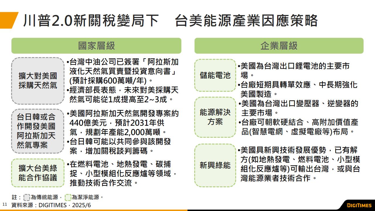
美国新关税变局下 台厂迎来储能电池、能源解方、新兴绿能合作契机
东南亚
苹果越南供应链成本升高 产品涨幅成未知数
东亚/中国
韩国半导体材料国产化迈步 全面自主仍有长路要走
半导体.零组件
英飞凌预计4Q25向客户提供首批12寸GaN样品
Semiconductors
Micron tightens grip on AI memory market as Samsung certification lags
半导体.零组件
(导论)美国、越南关税框架底定 「洗产地」防治仍待厘清
半导体.零组件
NVIDIA GB系列需求劲扬 台积电可望抵销汇率、关税风险
IT.系统供应链
安碁信息扩网安版图 泰国成东南亚优先落地市场
Research
美国新关税变局下 台厂迎来储能电池、能源解方、新兴绿能合作契机
东南亚
苹果越南供应链成本升高 产品涨幅成未知数
东亚/中国
韩国半导体材料国产化迈步 全面自主仍有长路要走
半导体.零组件
英飞凌预计4Q25向客户提供首批12寸GaN样品
Semiconductors
Micron tightens grip on AI memory market as Samsung certification lags
产业九宫格
先进国家市场
关税高利率双重打击 Lucid交车数与产量双双低于预期
关键零组件
从越南关税到泰国 台PCB业者忧东南亚适用相同税率
新科技/新商机
中国本土CPU、GPU加速校企人才结盟
移动通讯/电脑运算
NVIDIA GB系列需求劲扬 台积电可望抵销汇率、关税风险
新兴国家市场
(导论)美国、越南关税框架底定 「洗产地」防治仍待厘清
议题精选
供应链怎麽看美越关税?
议题精选
数据中心热潮席卷东南亚
议题精选
零里程二手车之乱
观点
杜念鲁
中印关系微妙 富士康运筹帷幄寻求多赢契机
廖家宜
拼国造无人机 商机在眼前却难入袋
黄女瑛
Wolfspeed破产 何以瑞萨、中美晶SiC受关注?
芮嘉玮
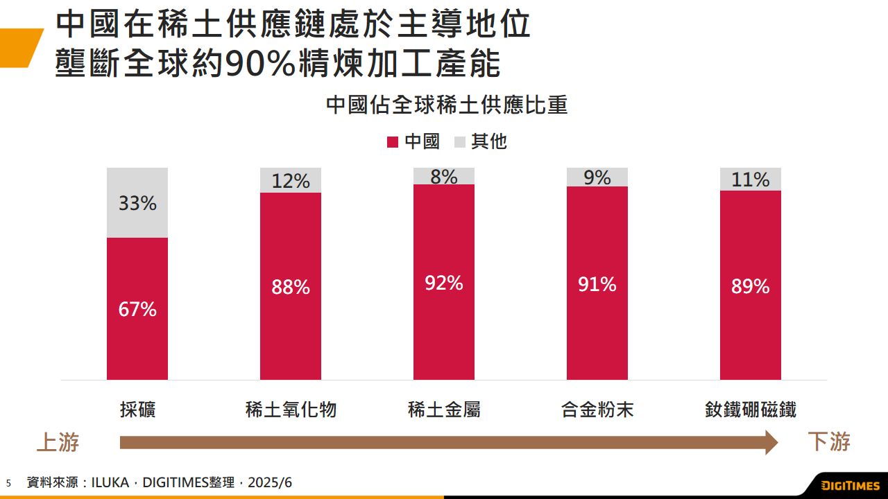
芯片换稀土?一场不对等的中美谈判底牌
三星传9月量产三折机 4Q25可望上市
2025/7/4
移动.通讯.XR
SSI CEO跳槽Meta Ilya Sutskever接替亲掌大权
2025/7/4
AI.智能应用.电商物流
富士康与川崎重工合作医疗机器人 2026年度台湾首发
2025/7/4
物联科技.智能制造
NVIDIA Blackwell Ultra领先部署 CoreWeave力抗云端三巨头
2025/7/4
半导体.零组件
大而美法案过关 美国7,500电动车购车补助9月30日结束
2025/7/4
CarTech.绿能
泓德旗下星星电力 AI超级大脑打造电力央行
2025/7/4
CarTech.绿能
广告
8/8 MCU再定义:从控制器迈向AI边缘智能核心
Research
车用零组件
中国稀土出口管制冲击全球汽车供应链 美欧日加速去中化与替代技术研发 短期内仍难摆脱依赖
Research
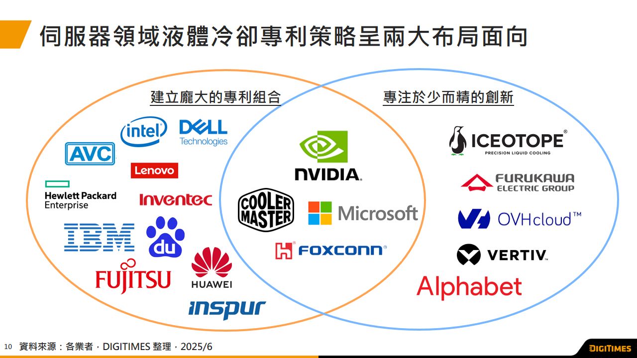
服务器
两相液冷技术能见度浮现 液冷专利布局同步上升
Research
电脑运算
2025/5 NB产业观察:北美教育标案需求不如预期 前五大NB品牌合计出货月增仅12%
Research
智能制造
工业机器人聚焦已知物抓取 人形机器人探索通用抓取能力
Research
CarTech
中美强权导入AI模型强化Robotaxi驾驶表现 偕出行平台供应商加速海外市场拓展
Research
IC制造
台积电仍将囊括2纳米制程多数订单 英特尔、三星受制良率难突围
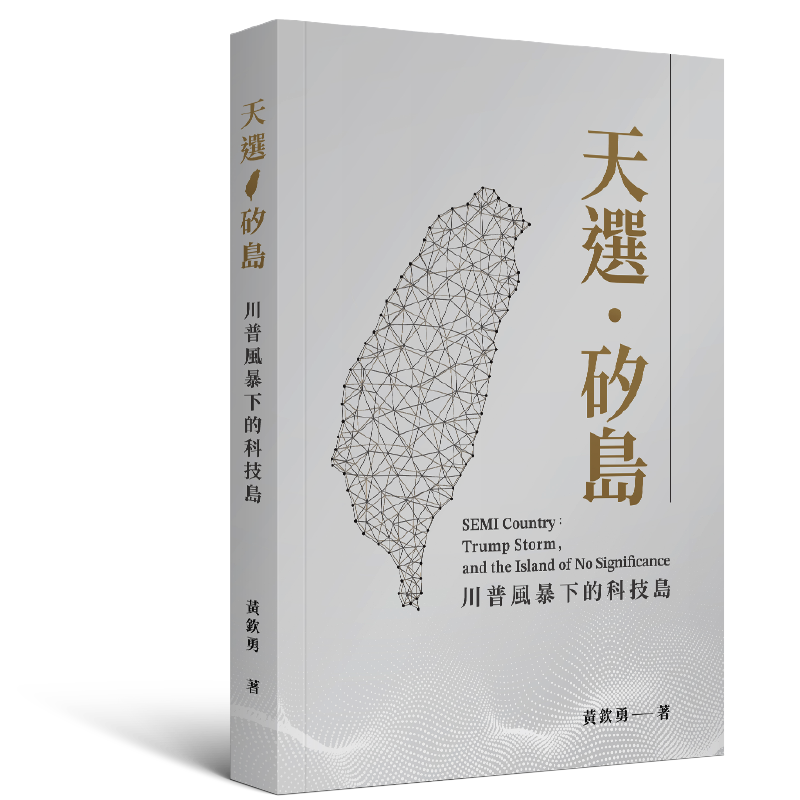
天选‧矽岛
川普风暴下的科技岛
作者|黄钦勇
AI浪潮来袭、川普风暴颠覆秩序之际,144公里宽的台湾却成为全球战略核心。本书剖析半导体产业竞逐,揭示台湾如何在国际角力中撑起全球供应链。突破重围,台湾是世界关键!
我要购买
最新报导
热门报导
热门查找
椽经阁
院长说院史(2):台湾第一座国立信息学院
院长说院史(1):台湾第一座国立信息学院
台湾量子电脑的发展策略
军事通讯—说码人加密
Edge AI产业来了吗?
热门影音
科技网近7日热门报导
1
印度芯片大计有多难? 解析「群丰破产、台积婉拒、力积保守」三大案
2
NVIDIA在台千人团队何处寻? Google、联发科AI人才身价飙
3
台积美国厂五大阻力减压 先进封装人事案2026拍板
4
陈立武削除官僚文化 英特尔晶圆制造部门也难逃裁员
5
日月光、台积电合攻面板级封装有谱 「310x310」成关键尺寸
科技网
智能应用
DIGITIMES
影音频道